Efficient asset management is key for organizations seeking to optimize operations, reduce costs, and enhance productivity.
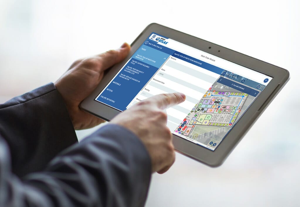
Arora ATLAS®, an enterprise-level suite of mobile products that integrates with IBM’s Maximo® Enterprise Asset Management (EAM) software, has taken a significant leap forward by introducing innovative new functionality. Now seamlessly integrated with ESRI’s Indoor GIS, ATLAS Indoor Maps is a powerful solution to simplify asset management and revolutionize facility maintenance workflows.
The integration enables organizations to effectively manage both outdoor and indoor assets while providing users with intuitive wayfinding and turn-by-turn navigation within complex indoor environments. The solution enhances operational efficiency, improves asset utilization, and facilitates informed decision-making.
Users will benefit from features like interactive indoor navigation, point of interest guidance, accessibility support, location-based services, and multi-floor navigation. This integrated solution streamlines workflows, optimizes facilities management, and empowers organizations with valuable insights for continuous improvement.
Arora ATLAS Indoor Maps revolutionizes indoor navigation by providing users with interactive and intuitive wayfinding solutions within complex indoor environments.
Leveraging the power of indoor mapping and location-based services, users can seamlessly navigate through buildings, finding the most efficient routes to their desired destinations.
Facility managers can empower employees, visitors, and technicians with turn-by-turn navigation, ensuring they can easily locate rooms, departments, amenities, or facility features. This not only saves time but enhances the overall experience within the facility.
ATLAS Indoor Maps empowers facility managers to seamlessly manage both outdoor and indoor assets by integrating asset data and location services.
With real-time tracking, monitoring, and maintenance capabilities, facility managers can efficiently oversee their asset inventory, identify asset locations, and proactively schedule maintenance activities.
By centralizing asset management and providing a holistic view of asset performance, this integrated solution enhances operational efficiency and reduces costly downtime.
The integration of Arora ATLAS and ESRI’s ArcGIS Indoors brings detailed indoor mapping and spatial analytics capabilities to facility managers and technicians.
With advanced tools and visualizations, ATLAS Indoor Maps will allow your organization to gain valuable insights into asset locations, movement patterns, and spatial relationships. This enhanced spatial understanding enables informed decision-making, improves operational efficiency, and optimizes resource allocation.
By leveraging these insights, facility managers can identify areas for improvement, streamline workflows, and enhance the overall efficiency of their operations.
Locating specific points of interest within large buildings can often be a challenging task.
Arora ATLAS Indoor Maps addresses this issue by offering users step-by-step directions and highlighting optimal paths to their desired points of interest.
Whether it’s finding a specific room, department, or amenity, users can rely on the integrated solution to guide them efficiently. This feature improves productivity, reduces confusion, and enables users to make the most of their time within the facility.
For multi-level buildings, knowing exactly what level the asset or workorder is located in and allowing for seamless navigation between different floors is essential to understanding the best way to locate said asset/workorder. Arora ATLAS Indoor Maps simplifies multi-modal floor-aware turn-by-turn navigation through places like staircases, escalators, or elevators.
Users can effortlessly move between floors, ensuring smooth vertical navigation. This functionality is particularly valuable in large office buildings, hospitals, shopping malls, and other complex facilities. By eliminating navigation barriers, facility managers can enhance accessibility, improve operational efficiency, and provide a seamless experience to users.
ATLAS Indoor Maps, the result of the seamless integration of Arora ATLAS with ESRI’s Indoor GIS, revolutionizes asset management and indoor navigation for facility managers. By harnessing the power of comprehensive asset management, enhanced spatial understanding, intuitive indoor navigation, point of interest guidance, and multi-floor navigation, ATLAS Indoor Maps streamlines workflows, optimizes facilities management, and empowers organizations with valuable insights for continuous improvement.
The result is improved operational efficiency, optimized facilities management, and valuable insights for continuous improvement. Facility managers who implement Arora ATLAS Indoor Maps can expect substantial time and cost savings while elevating the overall experience within their facilities. Embrace the power of Arora ATLAS Indoor Maps and revolutionize your asset management and indoor navigation practices today.
Contact our team today to learn more!