Facility management is a complex task that requires efficient utilization of resources and meticulous organization. In today’s business climate of rapid digitalization, implementing a mobile solution that pairs with your robust enterprise asset management (EAM) system, such as IBM’s Maximo EAM, is crucial.
Furthermore, facility managers can significantly enhance the efficiency of their efforts by choosing a mobile solution that integrates with ArcGIS Indoors.
By combining these powerful tools, facility managers can unlock a range of benefits that improve facility visualization, asset tracking, space management, work order efficiency, indoor navigation, and more. Facility managers who integrate Indoor GIS capabilities with their mobile EAM solution can save both time and costs while improving overall facility management outcomes.
Below, we outline five compelling reasons why investing in a mobile EAM solution that integrates with Indoor GIS will be a game-changer for your facility management operations.
Utilizing a mobile solution that integrates with ArcGIS Indoors enables facility managers to seamlessly manage both outdoor and indoor assets. By integrating asset data and location services, facility managers can achieve real-time asset tracking, monitoring, and maintenance. This integration eliminates the need for manual record-keeping and enables facility managers to access critical asset information on the go.
Facility managers can track asset movement, monitor maintenance schedules, and ensure timely repairs. By optimizing asset management processes, facility managers can minimize downtime, increase asset utilization, and reduce maintenance costs.
ArcGIS Indoors’ detailed indoor mapping and spatial analytics capabilities provide facility managers with enhanced spatial understanding. By integrating this indoor GIS with a mobile solution, facility managers can utilize the detailed and interactive indoor mapping capabilities to visualize their buildings and facilities accurately and gain insights into asset locations, movement patterns, and spatial relationships. These insights improve decision-making, operational efficiency, and resource allocation.
Facility managers can visualize assets in their exact locations, understand spatial constraints, and identify optimal asset placement. By utilizing spatial analytics, they can identify patterns of asset usage, identify potential bottlenecks, and optimize workflows. This integration empowers facility managers to make data-driven decisions, streamline operations, and enhance productivity.
An EAM mobile solution that integrates with ArcGIS Indoors offers intuitive and interactive indoor navigation capabilities. The integration provides users with turn-by-turn directions and wayfinding assistance within complex indoor environments. This ensures efficient navigation to desired destinations within buildings, reducing time wastage and enhancing user experience.
Facility managers can easily guide maintenance personnel or visitors to specific areas, assets, or facilities. This integration simplifies navigation within large buildings, multi-building complexes, or campuses, enhancing operational efficiency and reducing confusion.
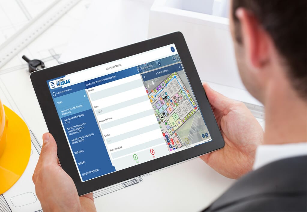
Integrating an EAM mobile solution with ArcGIS Indoors significantly enhances work order management. Facility managers can view and assign work orders directly on their mobile devices, leveraging the spatial information provided by Indoor Maps.
With a clear visualization of maintenance tasks’ exact locations, facility managers can assign technicians promptly, track work order progress in real time, and ensure timely resolution of issues. This integration streamlines the work order lifecycle, leading to improved response times, increased productivity, and enhanced customer satisfaction.
Integrating ArcGIS Indoors with an EAM mobile solution enables facility managers to assist users in locating specific points of interest and seamlessly navigate between different floors or levels within multi-level buildings. Users can easily find rooms, departments, amenities, or facility features by following step-by-step directions provided by the mobile solution.
The solution highlights optimal paths with instructions on floor transitions, staircases, escalators, or elevators, ensuring smooth vertical navigation and reducing time spent searching for specific locations.
This feature is particularly beneficial for new employees, visitors, or maintenance personnel who may be unfamiliar with the building layout. By providing accurate and efficient guidance, facility managers can enhance user experience, improve productivity, and streamline operations.
Facility managers can guide maintenance personnel to specific floors or assets efficiently, reducing time wastage and optimizing resource allocation. By enabling users to navigate indoor environments with ease, facility managers improve operational efficiency and overall productivity.
Integrating an EAM mobile solution with ArcGIS Indoors offers numerous advantages for facility managers seeking to optimize their operations.
From comprehensive facility visualization and real-time asset tracking to enhanced space management, streamlined work order processes, and improved indoor navigation, this integration empowers facility managers to make data-driven decisions, increase operational efficiency, and deliver better facility experiences.
By harnessing the power of these integrated solutions, facility managers can elevate their facility management practices to new heights, ensuring optimal resource utilization, improved maintenance outcomes, and enhanced occupant satisfaction.